
Editor’s note: This article has been updated following a Tuesday afternoon briefing.
COLUMBIA — No deaths or injuries had been reported in South Carolina due to Tropical Storm Debby as of Tuesday afternoon, but officials warned the worst flooding is still to come.
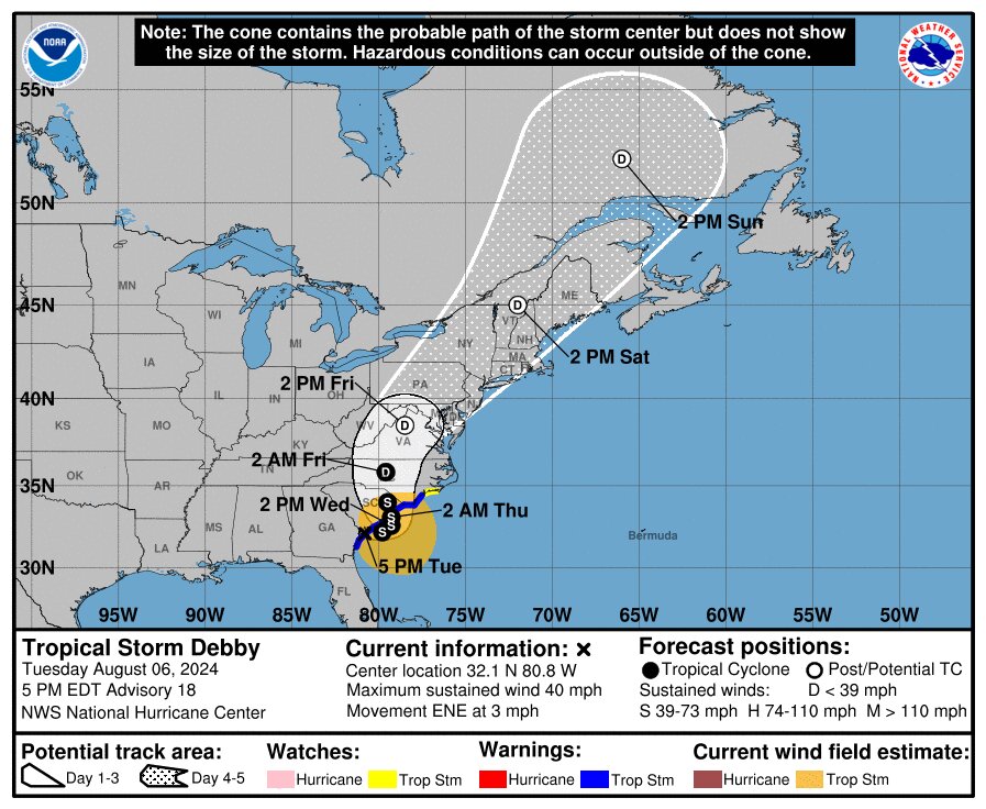
The slow-moving storm is expected to meander near South Carolina’s coast for a couple of days before returning ashore Thursday morning. That gives plenty of time for Debby to deluge the state, officials told reporters during a briefing at the South Carolina Emergency Operations Center in Columbia.
“A dangerous situation is unfolding across portions of the state, with life-threatening flash flooding ongoing,” said John Quagliariello, a meteorologist with the National Weather Service.
Tornadoes likely touched down in Edisto Beach, Kiawah Island, Moncks Corner, Lady’s Island, West Ashley and Isle of Palms, according to Quagliariello.
Winds have brought down trees, with gusts as high as 63 mph at Folly Beach and gusts topping 50 mph in other parts of Charleston and Beaufort counties, he said.
The National Hurricane Center reports tornadoes are possible along the coast through Wednesday morning.
“This is a storm that we have not seen before,” Gov. Henry McMaster said. “Parts of it have not been as bad as we thought, although it’s been bad. But there are some parts coming that likely will be worse than what we’ve seen before, and in different areas.”
Even after the storm clears South Carolina, floodwaters could continue to rise as rivers inundated in North Carolina flow south, he said.
“We will have to be alert for a long time,” he said.
However, he reiterated that he does not expect to order any evacuations.
The storm was responsible for four deaths in Florida, where Debby made landfall Monday morning as a Category 1 hurricane, and one in Georgia, according to The Associated Press.
So far, there are reports on damage to about 50 houses in Colleton County, said Kim Stenson, director of the South Carolina Emergency Management Division. But he cautioned those are preliminary numbers.
As of 1:30 p.m. Tuesday, 48 state roads were closed by flooding, said Transportation Secretary Justin Powell. While Interstate 95 remained open, ramps at Exit 22 near Ridgeland and Exit 33 near Yemassee had been closed due to flooding.
“More roads will flood,” he said.
Only one small dam in Colleton County has failed so far. Its rupture could contribute to local flooding, but it did not directly impact any homes or roads, said Myra Reece, interim director of the Department of Environmental Services.
Colleton County Fire asked residents near the McGrady Dam to evacuate this morning, but that was unnecessary, she said.
“There were reports it was failing. Actually, the emergency spillway was working as designed,” she said. “It was taking pressure off the dam.” She was unsure how many homes a breach of that dam would affect.
Colleton County has seen some of the highest rainfall totals so far, with 14 inches falling in Green Pond between Saturday and Tuesday night, according to the National Weather Service.
Edisto Beach, also in Colleton County, had already received nearly 13 inches of rain, while the highest total reported in the latest advisory fell in Summerville, at more than 17 inches. In Beaufort, 13.5 inches had fallen. Elsewhere in Beaufort County, just under 9 inches fell on Hilton Head Island, and just under 11 fell in Bluffton, according to the service.
Power has been going out across the state.
As of early evening Tuesday, 10,000 customers of Dominion Energy were without power, while Santee Cooper reported just 48. Duke Energy had some small outages in the state, including one in Greenville County that cut power for over 300 customers.
The city of Charleston extended a curfew, which started Monday night, through Wednesday, citing the amount of rain and gusts of wind up to 40 miles an hour. Main routes onto the peninsula remain closed, and an advisory by the city encouraged residents to stay home. Severe flooding is expected through Thursday.
The storm is still expected to bring 10 to 20 inches of rain to much of the state, although the maximum amount in some spots could be 25, rather than the 30 predicted Monday. Maps from the Hurricane Center show the worst of the rain north of Charleston and up the coast into North Carolina.
The risk of flash flooding remains high, at least 70%, along the entire coast. The risk is moderate through the Midlands and slight to marginal in the Upstate.
The Hurricane Center still expects storm surge of up to 4 feet along the Georgia and South Carolina coast, reaching all the way to southern North Carolina.
On Monday evening, President Joe Biden declared a state of emergency for South Carolina, allowing the Federal Emergency Management Agency to coordinate disaster relief.
Rivers may keep rising in SC from slow-moving storm for another week
BY: ABRAHAM KENMORE - AUGUST 7, 2024 6:20 PM
COLUMBIA — There may be a pause in the rain from Tropical Storm Debby, but Gov. Henry McMaster reminded South Carolinians the danger is far from over.
As of Wednesday afternoon, there were still no reports of fatalities or injuries from the storm, officials said.
“Things have not been as bad as they could have been, although we’ve had a lot of rain,” McMaster said a public storm briefing at the South Carolina Emergency Operations Center in Columbia.
“One way to look at this is we are in the second act of a three-act play.”
The first act came Tuesday as the storm dumped rain on the Lowcountry as it headed to the Atlantic Ocean. The second act will come as the storm returns ashore Thursday morning between Charleston and Myrtle Beach and moves through the Pee Dee, bringing 3 to 8 more inches of rain to much of the state.
Then as the storm heads north, all the water it dumps in North Carolina will flow downstream to rivers in South Carolina that could already be overflowing.
“Help your neighbors, look out for your neighbors,” McMaster said. “We know there will be a lot of cleanup to do and we’ve got to be very safe, because this is not nearly over.”
Some rivers may keep rising until the middle of next week. Those of particular concern for flooding include the Little Pee Dee River near Galivants Ferry in Horry County and the Edisto River near Givhans Ferry in Dorchester County, said John Quagliariello, a meteorologist with the National Weather Service.
At least three suspected tornadoes reported Tuesday have been confirmed, he said.
Those touched down on Edisto Beach, Kiawah Island and Moncks Corner. There are unconfirmed reports of another tornado at Edisto Beach along with Isle of Palms, West Ashley and Lady’s Island, Quagliariello said.
More than 6 homes have been damaged, with one destroyed, mostly in Colleton County. At least six businesses in Colleton, Berkeley and Horry counties also had some level of damage, said Kim Stenson, director of the South Carolina Emergency Management Division.
As of 11 a.m. Wednesday, 83 roads were closed, said Transportation Secretary Justin Powell, who noted that 25 roads that were closed due to the storm have been reopened.
Two ramps to Interstate 95 at Exit 22 and Exit 33 in Jasper County are open again after being closed by flooding. A ramp off Interstate 526 at Exit 15 in North Charleston also closed Tuesday afternoon, but it was open again by 7 p.m., according to the Department of Transportation.
As of late afternoon Wednesday, the stretch of coastal South Carolina north of Folly Beach was still expecting a storm surge of up to 3 feet, according to the National Hurricane Center.
As of 11 a.m., Summerville, outside of Charleston, has experienced the most rain at over 17 inches since Saturday, according to a National Weather Prediction Center report. Edisto Beach, Beaufort, Mount Pleasant and Charleston all had upwards of 13 inches of rain.
Around 5 p.m. Wednesday, there were roughly 1,500 Dominion Energy customers with power outages, while Santee Cooper had less than five. Duke reported some outages in the counties that it serves. None impacted more than 50 customers with the exception of 67 customers in Greenville.
The City of Charleston ended a curfew Wednesday morning that had begun Monday night.
Several school districts in the Lowcountry had school closures on Wednesday, and a number of districts through the Midlands and Pee Dee had e-learning days, according to the state Department of Education.
Abraham Kenmore is a reporter covering elections, health care and more. He joins the SC Daily Gazette from The Augusta Chronicle, where he reported on Georgia legislators, military and housing issues.
SC Daily Gazette is part of States Newsroom, the nation’s largest state-focused nonprofit news organization.
HELP FOR AGRICULTURE:
|
|


